Landsat Timelapse of Baker Valley and Phillips Reservoir
Understanding how our landscape changes over time is essential for responsible water management.
Thanks to the Landsat satellite program, we can look back across forty years of imagery to see how fields, vegetation, and water in Baker Valley have shifted through wet years, drought cycles, and evolving management practices.
Why do these images look blue?
These Landsat timelapse GIFs use a shortwave-infrared, near infrared, and visible composite, commonly called a false-color infrared composite. A false-color image is a picture where the colors have been intentionally changed to represent information we cannot normally see with the human eye. Satellite sensors, like those on the Landsat missions, detect many wavelengths of light (including infrared) which plants, soil, and water reflect in unique ways. Because our eyes cannot see infrared, the computer assigns visible colors—reds, blues, greens—to those wavelengths.
The blue tones in these GIFs represent different combinations of vegetation, such as irrigated farmland, forest lands, and shrublands. The deep black areas represent open water. This false-color approach makes gradual environmental changes easier to see and interpret across decades.
Baker Valley Agricultural Lands (1984–2023)
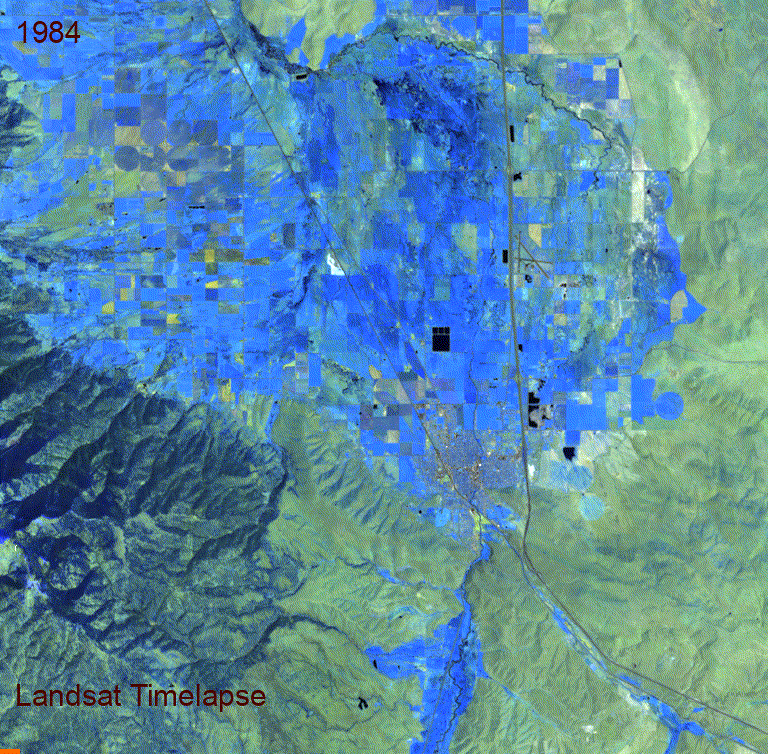
This Landsat timelapse shows four decades of change across the Baker Valley agricultural landscape.
The patchwork of blue and green fields represents crop rotations, irrigation patterns, vegetation cycles, and shifts in land use from 1984 to 2023. You can see hardly any expansion around Baker City’s limits and very few changes in the agricultural boundaries.
Phillips Reservoir and Mason Dam (1984–2023)
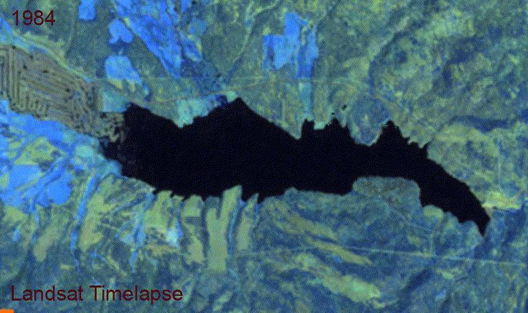
Phillips Reservoir was created when Mason Dam was completed in 1968, and it continues to serve the region today. The Landsat timelapse shown here covers the years from 1984 through 2023, which means it captures the latter portion of the reservoir’s full history. Even so, this forty-year slice reveals important patterns in how the lake responds to climate conditions and operational decisions.
In the timelapse, the black area represents open water, while the shifting lighter tones around the shoreline show exposed ground during low-water years. As the years progress, the reservoir expands and contracts with changes in snowpack, stream inflows, river outflow due to seasonal irrigation demand, and long-term climate cycles.
Viewed alongside the Baker Valley agricultural timelapse, the Phillips Reservoir animation helps illustrate how stored water, flowing water, and working landscapes are interconnected. These long-term visual records support better-informed decisions about conservation, operations, and planning for the future.
– Elaine –